Last week's Suspension Bridge visit showed that only 1 car in 100 in that traffic jam was texting. Maybe our Whiteladies Road "one car in 6" dataset was a fluke?
More study is needed, so here is another quick visit
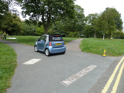
This time, DG54DFV is the vehicle with a driver texting. We should start collecting gender statistics. Today: female.
Maybe there is something to do with the fact that this is often the journey into town, the inbound route, which encourages texting. We should stop and ask people about why they are texting or checking facebook to understand this. Or perhaps delegate this task to Avon and Somerset Police
Monday, 16 September 2013

Thursday, 12 September 2013
Reminder: We are a data driven organisation that understands how things work
Some people -mistakenly consider us to be some kind of spoof, whereas in fact we are a documentary that has built up a weakly-defensible dataset of the city's transport issues.We also include topics like queue theory, game theory and the like to analyse that data.
This is why we despair when the legacy mass media publish articles that lack both real data and the fundamental understanding behind it
Now, Queue theory, Erlang's core concept: A queue happens when the egress rate of a channel is lower than the ingress rate.
In less technical terms "you get a queue if less things are leaving something than entering". It doesn't matter how big a bucket is, if more watering is pouring into it than is leaving from a hole in the bottom -eventually it will overflow
In evening post commenter terms "there's no point making something two lanes wide if it has to go down to one lane wide a bit further on". The bottleneck is the one-lane bit wide, not the two lane stretch.
We know this is hard to grasp, which is why people are still complaining about the Portway bus lane. Evening Post Commenters: the bottlenecks are the narrow bits beyond the suspension bridge and Anchor Road -removing the bus lane will not increase your journey time by car at all.
Alternatively: it is futile to remove a bus lane in the name of congestion, if there's a single-lane road later on. You are wasting your life on something that will not deliver the benefits you expect. You may argue against this using the term "common sense" -but that is why building things from bridges to computer networks rely on people called "engineers" trained in something called "mathematics". Common sense doesn't cut it when you actually want something to work.
The Evening Post reporters need to pick this up too.
As today there is an article, Traffic lights on Blackboy Hill 'are cause of the congestion'.
He conducted a survey and claims that the lights held up lots of buses.
Furthermore, if you are going to do a survey on congestion -why do it outside the rush hour. Do it at 08:30 at peak commute and school runs. Doing it after 9am is like saying the M32 doesn't get congested because you drove up it on a sunday morning.
Bad data, failure to root cause analysis and then pretending to care about public transport. We don't do any of these.
Mind you, Mr Brooks' pretence to care about buses doesn't make it through the article:
Sorry, but the congestion has other causes. It may seem frustrating to be stuck in a car watching bike lanes and bus lanes that are empty most of the time, but that is because they are working. The buses are not being held up until they merge with the cars on Whiteladies road; the bicycles not held up at all, mostly.
Here then is our dataset: a video from "wheels on the bike" counting the entire set of vehicles on Whiteladies Road, from the top to the triangle, in 1:45.
Most of Whiteladies road is one lane wide. That is the bottleneck -the carrying capacity of the road. Arguing about bus lanes up the hill or even switching times of traffic lights is irrelevant when there is a lane traffic jam from Park Row and Park Street stretching all the way up to the Downs.
This is why appearing on papers demanding for things to be removed because they "cause congestion" is dangerous. Someone may one day see this video and say "maybe there are other issues". We know that -it's the surburbanites driving into town. Simon Brookes should recognise this, and keep his mouth shut.
This is why we despair when the legacy mass media publish articles that lack both real data and the fundamental understanding behind it
Now, Queue theory, Erlang's core concept: A queue happens when the egress rate of a channel is lower than the ingress rate.
In less technical terms "you get a queue if less things are leaving something than entering". It doesn't matter how big a bucket is, if more watering is pouring into it than is leaving from a hole in the bottom -eventually it will overflow
In evening post commenter terms "there's no point making something two lanes wide if it has to go down to one lane wide a bit further on". The bottleneck is the one-lane bit wide, not the two lane stretch.
We know this is hard to grasp, which is why people are still complaining about the Portway bus lane. Evening Post Commenters: the bottlenecks are the narrow bits beyond the suspension bridge and Anchor Road -removing the bus lane will not increase your journey time by car at all.
Alternatively: it is futile to remove a bus lane in the name of congestion, if there's a single-lane road later on. You are wasting your life on something that will not deliver the benefits you expect. You may argue against this using the term "common sense" -but that is why building things from bridges to computer networks rely on people called "engineers" trained in something called "mathematics". Common sense doesn't cut it when you actually want something to work.
The Evening Post reporters need to pick this up too.
As today there is an article, Traffic lights on Blackboy Hill 'are cause of the congestion'.
A BRISTOL campaigner claims a set of traffic lights at a busy junction cause more congestion than they solve – and should be ripped out.We aren't sure what "campaigner" means here. Presumably it means "someone who doesn't understand queue theory but likes to get their face in the regional press"
Simon Brookes, who led a campaign for the removal of a controversial bus lane in Westbury Road, is now calling for the removal of the lights at the top of Blackboy Hill.
He conducted a survey and claims that the lights held up lots of buses.
Mr Brookes carried out another survey yesterday between 9am and 10am. He said he witnessed 89 changes of the lights and during that time, only two buses went through on green. But the number of buses going uphill and held up on a red was 26.We are surprised that Mr Brooks has now started caring about buses. Because if you are trying to get bus lanes removed on the approach to Whiteladies Road, suddenly caring about their performance in Whiteladies Road itself seems somewhat hypocritical -unless you are simply pretending to care.
Furthermore, if you are going to do a survey on congestion -why do it outside the rush hour. Do it at 08:30 at peak commute and school runs. Doing it after 9am is like saying the M32 doesn't get congested because you drove up it on a sunday morning.
Bad data, failure to root cause analysis and then pretending to care about public transport. We don't do any of these.
Mind you, Mr Brooks' pretence to care about buses doesn't make it through the article:
He will also be calling for a cycle lane to be removed from Westbury Park, where it meets with North Road.
He said the lane was not used by cyclists and simply added to traffic congestion.
Mr Brookes also wants to see the removal of the remaining stretch of bus lane from Westbury Park.
Sorry, but the congestion has other causes. It may seem frustrating to be stuck in a car watching bike lanes and bus lanes that are empty most of the time, but that is because they are working. The buses are not being held up until they merge with the cars on Whiteladies road; the bicycles not held up at all, mostly.
Here then is our dataset: a video from "wheels on the bike" counting the entire set of vehicles on Whiteladies Road, from the top to the triangle, in 1:45.
Most of Whiteladies road is one lane wide. That is the bottleneck -the carrying capacity of the road. Arguing about bus lanes up the hill or even switching times of traffic lights is irrelevant when there is a lane traffic jam from Park Row and Park Street stretching all the way up to the Downs.
This is why appearing on papers demanding for things to be removed because they "cause congestion" is dangerous. Someone may one day see this video and say "maybe there are other issues". We know that -it's the surburbanites driving into town. Simon Brookes should recognise this, and keep his mouth shut.
The Downs Committee joins the Bikelash!
Attached to Clifton are "the downs". You can recognise it by the way that all paths on the park have a big "No Cycling" sign -usually near some parked cars
The nominal reason they have the no cycling sign is to stop pedestrians and parked cars being damaged by cyclists.

In high summer, the Downs committee allows the Zoo (in exchange for money, obviously), to let visitors park on the downs, and bill the visitors for doing so.
In 2010 proposals to provide a park and ride alternative, were, rightfully, rejected.

It's quite clear what the Downs Committee wants. Nobody cycling on the pavement, people driving to the downs and parking on the grass.
Even so, council plans threaten it -and this week it is with a shocking proposal to make the speed limit in the park 20 mph!
Fortunately, the committee has come out and rejected it.
there we have it then. Total opposition to the proposals based on a single experiment of driving round at 20 mph, once, and noticing cars got upset.
We can expect the cycling campaigners to be a bit put out by this
Cllr Peter Abraham is the councillor for Stoke Bishop, whose residents have to drive over the downs to get anywhere. It's bad enough that the RPZ is going to remove a lot of parking opportunities, now they will be forced to drive a little bit slower.
As he said earlier. :
Lowering the speed limit in one of Bristol's main parks from 30 mph to 20 mph would only increase road rage, and, by encouraging people to walk and cycle round the park, increase problems!
This is why we support the actions of the Downs Committee. We also appreciate that many of the committee members are from the Society of Merchant Venturers. It is precisely because these people are chosen without democratic oversight that they are able to resist petty popularist policies like making parks safer for pedestrians and cyclists! Only they can represent the true voice of the evening post commenters!

The nominal reason they have the no cycling sign is to stop pedestrians and parked cars being damaged by cyclists.

In high summer, the Downs committee allows the Zoo (in exchange for money, obviously), to let visitors park on the downs, and bill the visitors for doing so.
In 2010 proposals to provide a park and ride alternative, were, rightfully, rejected.

It's quite clear what the Downs Committee wants. Nobody cycling on the pavement, people driving to the downs and parking on the grass.
Even so, council plans threaten it -and this week it is with a shocking proposal to make the speed limit in the park 20 mph!
Fortunately, the committee has come out and rejected it.
PLANS to bring in a 20mph speed limit on roads around The Downs have been opposed by the committee responsible for the open space.
The Downs Committee – made up of councillors and representatives from the Merchant Venturers – considered the proposals at their meeting yesterdayand voted against them by four votes to two, with one abstention.
Councillor Peter Abraham said: "I feel very strongly about this and I think we should oppose the 20mph limit being brought in on roads around the Downs."
Merchant Venturer Andrew Densham said he had attempted driving along the stretch at 20mph before the meeting and was greeted by flashing lights from fellow motorists.
"It is almost impossible to do," he said. "Going 20mph is absurd on most of those roads.
"I think the consequences of it would be more dangerous."
Fellow Merchant Venturer Anthony Brown said: "The traffic sub-committee asked what the experience had been on Ladies Mile and was told the average speed was 26mph and there are no major problems.
"If the speed limit is reduced people would do 20,16,18 and people would want to overtake. It was our view that it could be more dangerous."
there we have it then. Total opposition to the proposals based on a single experiment of driving round at 20 mph, once, and noticing cars got upset.
We can expect the cycling campaigners to be a bit put out by this
- Flat out refusal to provide safe alternatives to Ladies Mile or Sea Wall/ice cream van routes for bicycles
- Flat out refusal to consider lower speed limits that would benefit cyclists or even pedestrians trying to cross the road.
Cllr Peter Abraham is the councillor for Stoke Bishop, whose residents have to drive over the downs to get anywhere. It's bad enough that the RPZ is going to remove a lot of parking opportunities, now they will be forced to drive a little bit slower.
As he said earlier. :
I would much rather see the 30mph limit, which was only recently introduced, rigidly enforced. A 20 mph limit might be appropriate for some streets, but I think it will cause road rage incidents and a lot of frustration for motorists on The Downs."See: the council has already forced the speed limit down from 60 mph to 30 only ten years ago, and it is hard enough for his electorate to handle
Lowering the speed limit in one of Bristol's main parks from 30 mph to 20 mph would only increase road rage, and, by encouraging people to walk and cycle round the park, increase problems!
This is why we support the actions of the Downs Committee. We also appreciate that many of the committee members are from the Society of Merchant Venturers. It is precisely because these people are chosen without democratic oversight that they are able to resist petty popularist policies like making parks safer for pedestrians and cyclists! Only they can represent the true voice of the evening post commenters!
Wednesday, 4 September 2013
Better texting data: only 1 driver in 100 does it
Our morning surveys show that about 1 in 5 drivers stopped at a light is texing or phoning. Pretty damning -but there could be selection bias. The lights stop the drivers who aren't aggressive -possibly because they are on the phone. And its one route, morning only.
More data is needed.
Here then is a short video of the route from Ashton Court to Clifton, initially showing a line of stationary traffic on the A369 (Portishead and M5 Gordano Services exit), heading down to town. Ignore them: our dataset is the line of vehicles heading to the junction from the Clifton Suspension Bridge. It's great for a survey: a row of stationary vehicles, easy to measure from the other side of the road, and because of the toll, many people have their window down.
Count the cars, and see if you can spot the one texting
For the inattentive, it's the Audi 1:88, where both driver and passenger are tapping away on their smartphones. That's the car with the custom number plate RJZ1066, to show how important they really are.
Sadly, even though they are important, they are stuck behind 70+ other vehicles driven by people who also think that they are important, so the Audi driver has to text ahead and perhaps add updates on facebook. It is selfish commuters who are holding up the important people from getting home from Clifton.
What's important is that the new data shows that the claims that 1 driver in 5 is texting at lights is clearly false -at least here, on a weekday evening.
More data is needed.
Here then is a short video of the route from Ashton Court to Clifton, initially showing a line of stationary traffic on the A369 (Portishead and M5 Gordano Services exit), heading down to town. Ignore them: our dataset is the line of vehicles heading to the junction from the Clifton Suspension Bridge. It's great for a survey: a row of stationary vehicles, easy to measure from the other side of the road, and because of the toll, many people have their window down.
Count the cars, and see if you can spot the one texting
For the inattentive, it's the Audi 1:88, where both driver and passenger are tapping away on their smartphones. That's the car with the custom number plate RJZ1066, to show how important they really are.
Sadly, even though they are important, they are stuck behind 70+ other vehicles driven by people who also think that they are important, so the Audi driver has to text ahead and perhaps add updates on facebook. It is selfish commuters who are holding up the important people from getting home from Clifton.
What's important is that the new data shows that the claims that 1 driver in 5 is texting at lights is clearly false -at least here, on a weekday evening.
Wednesday, 28 August 2013
Archaeologists seek the fabled "lost cycle lane of Stokes Croft"
It's long been claimed that there is a pre-roman era cycle lane on Stokes Croft, hidden under the parked cars.
We now have a video of an archaeological dig that set out to explore this and other historical artifacts of the area
There ae some sightings of the fabled lost bike lanes of stokes croft at 3:07 and 4:45
Some viewers may be surprised by the fact that the university professor didn't know much about living on the Isles of Turbo, even though the university is 0.8 miles away. Remember, Bristol measures its status in vertical metres, the uni is near the top of the hill, whereas from Turbo Island the only place left to go down is the bear pit.
Even so, Stokes Croft does not like to deny opportunities to anyone -all university faculty members are invited to the island, just bring your own drinks. Some ethanol from the chemistry department would go down a treat.
Thursday, 22 August 2013
Suspension Bridge response: these are not the build-outs you are looking for
A few of our cycling-troublemakers objected to the build-out at the junction with Observatory Road, on the basis this would increase car/bicycle conflict.
This argument was dismissed with this simple reposte: there are no build outs on Suspension Bridge Road.

This is fantastic, because it not only destroys all objections to the build out -it makes the cyclists question their own sanity.
Do they see build-outs on Suspension Bridge Road and Gloucester Row? They aren't there. Those bits on the map where they say "proposed footway build outs with dropped kerbs"? They aren't there.
This is as great a way of dealing with objections as the "the cycling group said it was OK". Here you don't need to even reference that, you just say "you are mistaken, there are no build outs on that road".
Presumably this explains the appearance of buildouts over the uphill bike lane on nearby whiteleadies road. They aren't there either, and anyone who complains about them is mistaken,
This argument was dismissed with this simple reposte: there are no build outs on Suspension Bridge Road.

This is fantastic, because it not only destroys all objections to the build out -it makes the cyclists question their own sanity.
Do they see build-outs on Suspension Bridge Road and Gloucester Row? They aren't there. Those bits on the map where they say "proposed footway build outs with dropped kerbs"? They aren't there.
This is as great a way of dealing with objections as the "the cycling group said it was OK". Here you don't need to even reference that, you just say "you are mistaken, there are no build outs on that road".
Presumably this explains the appearance of buildouts over the uphill bike lane on nearby whiteleadies road. They aren't there either, and anyone who complains about them is mistaken,
Wednesday, 21 August 2013
Suspension Bridge: Council to objectors: go away
Here then, as promised, is the council's response.


- The council cycling QA team reviewed it -and didn't object.
- Therefore there are no problems with the route.
- Therefore all the objectors are mistaken
- So their objections will be ignored.
This is fantastic! It shows the way forward for building pro-car designs in an anti-car city. All we have to do is involve the cycling team at the last minute, get some inadequate review from them -and we've got a green light to do what we want.
Once the cycling team at the council say there is nothing wrong with a route, all objections from cyclists can be discounted.
The best bit: the cycle team will get the blame, but by the time they get to find out, it's too late. And now we can use their "they didn't say no" response to ignore all other objections, the council road team must be laughing:
The best bit: the cycle team will get the blame, but by the time they get to find out, it's too late. And now we can use their "they didn't say no" response to ignore all other objections, the council road team must be laughing:
Consultation comments and responses, Summer 2013
RS12088 Suspension Bridge Road Highway Improvement Works
-
Please consider closing Observatory Road to non‐coach and non‐cycle traffic; there is a very
suitable alternative route via the mini roundabout and this would unify the green areas,
The feasibility of this is now being investigated and traffic counts are being arranged to assess the impact on the wider road network. If it is deemed workable then steps will be taken to procure the Traffic Regulation Order, including public advertisement of the proposals, when there will be opportunity for comments to be made,
-
Please consider making Observatory Road one way (southbound) for coaches and two‐way for
cyclists,
The proposed coach drop off point is designed for coaches to access by turning off Suspension Bridge Road (SBR), ie heading northbound on Observatory Road. Not only does this design make use of an historic ‘layby’ area, thus minimising the change of the road layout, but exiting Observatory Road from its northern end makes use of an easier junction than turning out of the bottom. Foreign coaches would, however, need to travel southbound in order to access the drop off point and allow passengers to alight onto the footway. Observatory Road would be kept two‐ way for cyclists, if a closure to non‐coach traffic was progressed,
-
Please consider installing one or two zebra crossings on Observatory Road if it remains open to
general traffic,
Controlled crossings, such as zebras, should be installed on established pedestrian ‘desire’ lines, i.e. on established routes where pedestrians already cross; the ‘desire’ lines across Observatory Road are across the junctions at each end. Controlled crossings are expensive, and the installation costs would be difficult to justify here if Observatory Road was to be partially closed, as discussed in 1, due to the reduced traffic volume,
-
Use different surfaces across the mouths of side roads to affirm the presence and priority of
pedestrians over turning vehicles,
The primary purpose of surface treatment in this context is to prevent skidding under sharp braking on the approach to pedestrian crossings, but it also serves to warn motorists in advance, of the possibility of pedestrians being in the road. It would not be appropriate, therefore, to just lay a strip of surfacing across a junction, but a larger area would be treated, including the approach roads, such as is proposed on SBR in the area between the two tables. We would not wish to encourage pedestrians to cross SBR in the vicinity of its junctions with Observatory Road and Sion Hill, due to the various turning movements here, but rather to use the zebra crossing near The Mall or the proposed tables a little further west. We would not, therefore, lay surface treatment on the SBR approaches to the side road junctions, but limit its use to giving warning of, and protecting, the two areas mentioned, where more formal crossing points are already in place or are proposed,
-
Very difficult to cross Sion Hill – Sion Place, please build out between the junctions,
It is currently proposed to build the footway out between Sion Hill and Sion Place in order to
reduce the width of the wide junction, to facilitate pedestrian movement and also slow traffic
turning left from SBR, down into Sion Hill,
-
Crossing Gloucester Row can be difficult and dangerous because of the heavy traffic flow. The
changes will make this worse (increasing coach traffic), particularly endangering pedestrians
seeking to cross Observatory Road,
It is not considered that installing a coach drop off point on Observatory Road will significantly increase the total amount of traffic travelling along SBR / Gloucester Row. An estimate of visiting coach numbers is an average of 3 per day, with an expected maximum of 5 per day. Partially closing Observatory Road, as discussed in 1, is likely to increase traffic volume along this road, however, and this will be considered when the feasibility is assessed. It would, however, also reduce the amount of turning movements at the junction of SBR and Observatory Road, arguably making it simpler to cross. There is also a zebra crossing a little further up the Mall, where priority is given to pedestrians to be able to cross,
-
Please ensure that the junctions at the top of Sion Hill and Sion Place are not narrowed too
much,
All new road layouts are checked that they are able to be tracked by large vehicles as part of the design process,
-
The southernmost footway on SBR is too narrow, this could be closed and a new footway could
be cut across the Downs,
Given the pedestrian desire lines across SBR on the approach to the bridge, particularly on the route to the childrens’ play park, it would be necessary to keep the existing footway on the southern side. The foliage and bank has encroached over the footway opposite the public conveniences, and it is proposed to restore the width of the footway here,
-
The dropped kerbs in the build outs at the end of Observatory Road are on the widest part of the
junction, putting pedestrians at risk,
The proposed dropped kerbs will be moved back to the existing position,
-
Consider installing a raised crossing across the end of Observatory Road, in order to slow traffic,
A raised crossing could be a very useful item here, provided it was set back from the junction to allow cyclists to straighten up before negotiating the ramp. It would, however, be unnecessary if Observatory Road was to be partially closed, as discussed in 1, due to the reduced traffic volume,
-
Removal of the pedestrian refuge island at the junction of Observatory Road and SBR is not safe
for pedestrians, due to the speed of traffic exiting SBR and queueing on Observatory Road,
It is considered that the proposed built out footways in the junction will reduce the speed of traffic turning into Observatory Road, making the junction easier to negotiate as a pedestrian. Furthermore the crossing width is also proposed to be reduced. It is understood, however, that the existing refuge island is useful in allowing pedestrians to cross one stream of traffic at a time.
It would, however, be unnecessary if Observatory Road was to be partially closed, as discussed
in 1, due to the reduced traffic volume,
-
Formal crossing points should be installed across SBR, rather than tables,
Although there are several main pedestrian desire lines across SBR, on the route to the childrens’ play park and near the public conveniences, pedestrians do wander across the road between these points and also closer to the bridge, across the central reserve. Research shows that controlled crossings are not necessarily suitable for areas where there is a ‘scatter’ of crossing movements, rather than distinct desire lines, perhaps because motorists are focussing on the crossing itself rather than who may be crossing elsewhere. The proposed 20mph limit (being proposed as a separate scheme), together with the proposed speed tables should slow the traffic so that pedestrians are more able to negotiate SBR without the need for formal controlled crossings,
-
Slower traffic along SBR will be more dangerous for pedestrians to cross between as it will be
more bunched up,
It is unlikely that slowing the traffic will result in it being bunched up and therefore difficult for pedestrians to negotiate, rather traffic will undoubtedly slow for the speed tables, allowing slightly more gaps. It is hoped that the slower speeds, together with the raised areas may even encourage some drivers to actually give way to pedestrians at the tables,
-
The Sion Hill build out can not be used by people in wheelchairs as they can not negotiate the
steps at The Mall end of the footway, near the zebra crossing,
People in wheelchairs would be able to use the proposed crossing point across Observatory Road, with great ease if Observatory Road was to be partially closed, as discussed in 1, due to the reduced traffic volume,
-
Turning right from Observatory Road onto SBR is tricky on a bicycle in heavy traffic,
If Observatory Road was to be partially closed, as discussed in 1, turning movements into and out of the junction would be negligible, reducing the potential for conflict at the junction. Traffic flow along SBR is likely to increase, but the zebra crossing near The Mall will continue to provide gaps when the traffic is flowing freely. When traffic is backed up and at a crawl during peak time, there would be limited impact, except for the positive effect of the reduced turning movements,
-
The westbound cycle lane on SBR approaching the bridge is too narrow, especially where the
central reserve starts, and part of it is cobbled,
There is limited scope for widening the cycle lane on the bridge approach along SBR. Where the central reserve starts it is necessary to maintain a narrow traffic lane in order to ensure that the weighbridge takes the full axle load of heavy vehicles, from both wheels. The feasibility of widening the carriageway directly after the weighbridge is being investigated, in order to widen the cycle lane through this pinch point. It is not feasible, as part of this scheme, to meaningfully widen the approach cycle lane, as this would mean widening the highway corridor over the common land, a strip of full depth carriageway construction, relaying of a long length of granite sett channel, drainage works and reconstruction of the whole footway; this could not be carried out within the scheme budget,
17. The westmost table, can the carriageway be widened to widen the cycle lane, please?
As discussed in point 16, the feasibility of widening the carriageway directly after the
weighbridge is being investigated, in order to widen the cycle lane through this pinch point,
-
Please consider a segregated cycle lane along Suspension Bridge Road (SBR),
As discussed in point 8, given the pedestrian desire lines across SBR on the approach to the bridge, particularly on the route to the childrens’ play park, we deem it necessary to keep the existing footway on the southern side. There is therefore no space within the existing highway corridor for a segregated cycleway along SBR,
-
The build outs at the end of Observatory Road create a pinch point for cyclists,
If Observatory Road was to be partially closed, as discussed in 1, it would not be used for general traffic and cyclists would, for the majority of the time, have the road to themselves,
-
Please introduce a 10 or 15mph limit for safety and structural reasons and a ‘no overtaking’
restriction on the bridge,
The Bridgemaster is satisfied that a 20mph limit is suitable for the structural needs of the bridge. This is also the slowest limit which is permitted to be imposed on the public highway. We have forwarded the comments regarding a ‘no overtaking’ restriction to the Bridgemaster,
-
It is not clear that the works have been formally assessed with regard to cycling. This should be
done,
The proposals have been formally assessed with regard to cycling, as part of the Council’s ‘quality assurance’ design process,
-
Extend the central reserve onto the bridge with other measures to discourage overtaking,
We have forwarded the request for the extension of the central reserve onto the bridge to the Bridgemaster,
-
Appropriate signing would be useful to draw drivers’ attention to cyclists,
Part of the scheme’s brief is to reduce and rationalise highway signing in the area. It is not considered necessary to introduce further signing to draw attention to cyclists,
-
The speed tables should have bypasses for cyclists as they are too sharp and deteriorate leaving
a dangerous surface,
The ramps of the speed tables are proposed to be sinusoidal in profile and the ramps are proposed to have flat tops. This is different to the usual design which is more angular and sharp. The ramps are only proposed to be 75mm high. It is considered, therefore, that they will pose no danger to cyclists,
-
The existing cycling drop off from the toll bypass is not in a good position and this is worse with
the new ‘quick’ barriers,
We have forwarded the comments regarding the cycling drop off position and the new barriers
to the Bridgemaster,
-
The tables should have high friction surfaces to avoid slipping in winter / wet weather,
Given the proposed gentle profile of the speed tables, as discussed in point 24, it is not considered necessary for them to have a high friction surface. Nevertheless we do intend to lay buff surface treatment on and between the tables, as discussed in point 4, to warn motorists of an area in which pedestrians are likely to be in the road,
-
The approach road should be a ‘shared surface’,
The civil engineering works which would be necessary in order to make SBR a shared space could not be carried out within the scheme budget,
-
The central reservation should be removed allowing wide cycle lanes to be introduced,
The central reservation must remain in place, in order to ensure accurate weighing of large vehicles on the weighbridge, as discussed in point 16,
-
Please consider the second (unnamed) road opposite Christchurch for a bus drop off point as it is
flat, or on the Promenade,
It is likely that if a coach drop off bay was introduced too far away from the bridge, then coaches would still drop off passengers close to the bridge, and the hazard of coaches stopping on Observatory Road would remain,
-
Consider left hand drive foreign coaches, when children will be alighting into the road rather
than onto the footway – can a sign be erected to encourage foreign drivers to pull in wrong
direction so that children can alight onto the footway?
There is no approved sign which can be used for this purpose; foreign drivers would need to pull over onto the ‘wrong’ side of the road in order to allow their passengers to alight safely. This could also be done within the proposed coach drop off bay, and one would assume that such drivers would be used to this issue and be prepared to do so,
-
A coach exiting the drop off bay will be dangerous when it turns onto SBR,
Coaches would need to access Observatory Road from the south in order to access the coach bay. This would mean that they would not normally be exiting via the southern junction of Observatory Road, but via the northernmost junction,
-
Coaches could be queueing as they wait for their slot at the drop off point,
Given that the area typically receives around 3 coaches per day, with an expected maximum of 5, and that coaches will only be permitted to drop off here, it is unlikely that this will be a significant issue,
-
The 10 minute drop off time will be abused,
The coach bay would need to be enforced, in order to ensure turn over, and should problems
occur then extra enforcement would be requested,
-
Currently coaches drop off on the far side of the Downs and drive down the road towards
Central Bristol (ie towards Pembroke Road) rather than impinging on Clifton Village,
Currently coaches also drop off along Observatory Road and Sion Hill, blocking the road and causing traffic to overtake in dangerous positions,
-
Coaches should not be encouraged to drop off so close to the bridge,
Practically, as discussed in point 29, if a coach drop off bay was introduced too far away from the bridge, then coaches would still drop off passengers close to the bridge, and the hazard of coaches stopping on Observatory Road would remain,
-
The coach drop off point should be just painted on the road to save expense and avoid loss of
Downs land,
If a coach bay was just painted on the road, rather than being in a layby, then the hazard of a parked coach which needs to be overtaken would remain. The purpose of this design is to provide a safe stopping place for coaches, where pedestrians can alight safely and walk to the bridge safely,
-
A drop off point on Observatory Road would need to be about 2‐5 minutes drop off, to ensure
that they do not stay there if they are only in the area for about 1⁄4 hour. This would also ensure
that coaches can access the point, rather than circling the Downs waiting for space to stop.
Coaches waiting might just wait on Observatory Road till they can turn right and pull in, causing
congestion. Proper enforcement of the restrictions would be needed,
A 5 minute drop off time is unlikely to be long enough to allow a coach to return and stop to wait for passengers to board after visiting the area. As discussed in point 33, the restriction would need to be enforced,
-
The ‘no return within 1 hour’ restriction will be a problem; do people stay in the area for an
hour? If not, then buses will be returning illegally, perhaps this time period needs to be reduced,
This is a good point, the proposed restriction is to be changed to, ‘10 minutes, no return within 30 minutes’,
-
Thinks tourists miss the village, they only visit the bridge. Can some sort of signing be installed to
direct them to the village?
Investigation will be made into provision of a pedestrian sign, pointing towards Clifton Village, in order to encourage tourists to visit,
-
What about encouraging people to visit the national trust woodland in the Leigh Woods area?
Speak to the National Trust,
Communication will be made with the National Trust, although priority for funding will be given to encourage visitors to visit attractions within the city boundary,
-
Advanced weight limit warning signs for all bridge approaches could be useful,
A sign survey will be carried out in order to find out any deficiencies in the highway signing,
-
Could do with a flashing ‘weight limit’ sign, like a VAS,
It would not be necessary for a sign to flash for all vehicles approaching the bridge, but only for large vehicles, like a speed limit sign only flashes for vehicles which are travelling too fast. While this is a good idea, in order for it to work it would have to be sited on SBR, near its junction with Sion Hill, and would clearly have to be activated by some means, meaning that the weighbridge would also have to be moved. The weighbridge is positioned where it is, so that if a large vehicle were to drive on the other side of the road in order to avoid being weighed, then this practice would be visible from the bridge toll booth and action could be taken to stop the vehicle. This could not so easily be done if the weighbridge was near Sion Hill. Nevertheless we have forwarded this comment to the Bridgemaster for his consideration,
-
Can Parks be prevailed upon to improve the steps which are approx. 30m s/w of Observatory
Road? Also the slope down to the eastmost proposed table is treacherous in winter – can this be
relaid with a rougher tarmac?
Subject to funding, the steps will be reconstructed as part of the scheme. The comment about the slope condition will be forwarded to the Parks team for their consideration,
-
Railings on the northern side of the eastmost proposed table – please restore the railings which
are bent and need painting. They should be moved rather than shortened!
The railings will not be shortened but rather be repositioned and restored,
-
By the WCs, there are 3 or 4 concrete posts around the WCs, with no fencing on them so they
are redundant, please remove,
The posts will be removed as part of the scheme,
-
BT pole in footway west of the toilets, is the post redundant (don’t think so actually)? If so
please remove,
We will contact BT to ascertain the need for the post, or otherwise, and if it is not needed ask them to remove it,
-
Please maintain the loose kerbs on the bends,
The loose kerbs will be maintained or replaced as part of the scheme,
-
There was a sign reading, “To the public lavatories” which was removed some time ago, it was
on a l/c, just east of the eastmost proposed table. It was taken to store, please can this be
restored and repositioned?
There is no record of such a sign being in store,
-
Scruffy around the WCs, whose responsibility is this?
The area around the public conveniences is the responsibility of the Parks team and the
comments regarding the need for maintenance will be forwarded to them for their
consideration,
-
The bin in the build out near the central reserve, on the bridge approach, is in the pedestrian
desire line,
The bin will be moved as part of the scheme, so that it is not in the main pedestrian desire line,
-
The westmost table is too near the weighbridge, please move to the western side, 5m beyond,
The westmost table has been moved so that it is on the other side of the weighbridge, so that it will not affect the accuracy of the weighing system. This is actually in a better place with respect to pedestrian movements across SBR,
-
The shrubbery along the southern side of SBR should not be cleared out due to the birds and
also it forms a screen against traffic, the toilets and the rocks to residents of Sion Hill,
This matter has been discussed with the Parks team and the Downs Ranger and it is agreed that the undergrowth should be cleared out from underneath the trees. The purpose is to open up the pedestrian route to the bridge, which is currently dark and constricted. The aim is to let in light, improve the views and accessibility between the trees and ensure that the maximum footway width is maintained. Small trees will be removed and the ground will be grass seeded. There are plenty of ‘wild’ areas for fauna in the area and this area will be improved for people using the area. The proposed 20mph speed limit, mentioned in point 12, should moderate traffic speeds and noise,
-
Why is the weighbridge so close to the bridge rather than near the Sion Hill junction?
This comment is answered in point 42.
Tuesday, 20 August 2013
Suspension Bridge, objection #3
Another objection we saw, an other naive fool expecting that their input would actually be read, let along act on it. For now, cherish the effort they put in with the expectation that someone would actually read it.
Again, a video of the strangely green and wooded land over the bridge, in the Elf-Kingdom of North Somerset. Many important people live there, and people on bicycles interfere with their lives, both here at the weekend and on the weekday commutes. Discouraging cycling is necessary -no doubt they shall be grateful to BCC for what they are promising
(This is Stella Nova trail; Strava notes that this tax-dodger is only just in top 25% of riders, so they lack both skill and fitness.
And now, the letter:
Dear Mr Sarson,
Consultation Response: RS12088 : Proposed Improvement works Suspension Bridge Road area
I am an occasional user of the Clifton Suspension Bridge, mostly by bicycle, mostly in an inbound direction.
There appears to be significant cycle traffic across the bridge, and it is important that cycling aspects should be taken into account in any modifications. Cycle traffic is generated by the Ashton Court park, general access to the countryside, and possibly by local commuting. Additionally I am aware of long distance commuting from Pill.
1. It is not clear whether the works have been formally assessed with regard to cycling. This should be done.
2. Although the proposals correctly identify the area as one needing a treatment based on the considerable pedestrian traffic generated by the bridge, gorge and surroundings, and that pedestrian movement should be facilitated this has not been carried to the correct conclusion of adopting a much lower speed limit throughout the entire area from the Sion Hill junction to a similar point beyond the bridge on the other side. For road safety and structural reasons a limit of 10 or 15 mph would be appropriate.
3. (a) The narrowness of the road means that particular attention should be given to the safety of cyclists. Paradoxically the safest part of the road is probably the exit section where the carriageway divider means that it is obvious that overtaking is impossible and where it is almost impossible for a cyclist to ride in a position that suggests that overtaking is desirable. This fact should be considered with regard to the whole area, in particular the dangers of the existing narrow cycle lane on the Leigh Woods side should be reviewed, with particular regard to its tendency to suggest that cyclists can be overtaken in the bridge approach.
(b) I agree with the retention of the central carriageway dividing strip, and suggest that this could be extended onto the bridge, with other measures to discourage overtaking, in particular the speed limit suggested above.
(c) Appropriate signing to draw drivers attention to the need to take care of cyclists would be useful.
4. The proposed safety tables give rise to some concern. Safety tables tend to be too sharp for cyclists and suffer structural deterioration fairly quickly, creating a dangerous surface. I suggest that the existing safety table design, covering half the road and therefore being completely bypassed by cyclists is the best concept.
5. (a) The provision of a short term coach drop off point in Observatory Road could be done at minimal expense and disruption simply by painting a box on the road. The net loss of land on the Downs is bad in principle and in practice, since it pushes the greensward further back. The expense of the proposed works to construct a coach drop off is entirely unnecessary.
(b) Since the buildouts are presumably intended to discourage traffic from entering Observatory Road it would be logical to close this road completely except to cycles and coaches, facilitating use of the road by cyclists and as a coach drop off point. Without this the buildouts themselves become an additional hazard for cyclists. There is no obvious reason why Observatory Road is needed as a route for through traffic. Closing it to most motor traffic would unify a green area extending a considerable further distance towards Christ Church.
6. The review of the Sion Hill junction should extend back over the whole length of Suspension Bridge Road, which is not an attractive road to cycle on.
Yours sincerely,
"W"
Again, a video of the strangely green and wooded land over the bridge, in the Elf-Kingdom of North Somerset. Many important people live there, and people on bicycles interfere with their lives, both here at the weekend and on the weekday commutes. Discouraging cycling is necessary -no doubt they shall be grateful to BCC for what they are promising
(This is Stella Nova trail; Strava notes that this tax-dodger is only just in top 25% of riders, so they lack both skill and fitness.
And now, the letter:
Dear Mr Sarson,
Consultation Response: RS12088 : Proposed Improvement works Suspension Bridge Road area
I am an occasional user of the Clifton Suspension Bridge, mostly by bicycle, mostly in an inbound direction.
There appears to be significant cycle traffic across the bridge, and it is important that cycling aspects should be taken into account in any modifications. Cycle traffic is generated by the Ashton Court park, general access to the countryside, and possibly by local commuting. Additionally I am aware of long distance commuting from Pill.
1. It is not clear whether the works have been formally assessed with regard to cycling. This should be done.
2. Although the proposals correctly identify the area as one needing a treatment based on the considerable pedestrian traffic generated by the bridge, gorge and surroundings, and that pedestrian movement should be facilitated this has not been carried to the correct conclusion of adopting a much lower speed limit throughout the entire area from the Sion Hill junction to a similar point beyond the bridge on the other side. For road safety and structural reasons a limit of 10 or 15 mph would be appropriate.
3. (a) The narrowness of the road means that particular attention should be given to the safety of cyclists. Paradoxically the safest part of the road is probably the exit section where the carriageway divider means that it is obvious that overtaking is impossible and where it is almost impossible for a cyclist to ride in a position that suggests that overtaking is desirable. This fact should be considered with regard to the whole area, in particular the dangers of the existing narrow cycle lane on the Leigh Woods side should be reviewed, with particular regard to its tendency to suggest that cyclists can be overtaken in the bridge approach.
(b) I agree with the retention of the central carriageway dividing strip, and suggest that this could be extended onto the bridge, with other measures to discourage overtaking, in particular the speed limit suggested above.
(c) Appropriate signing to draw drivers attention to the need to take care of cyclists would be useful.
4. The proposed safety tables give rise to some concern. Safety tables tend to be too sharp for cyclists and suffer structural deterioration fairly quickly, creating a dangerous surface. I suggest that the existing safety table design, covering half the road and therefore being completely bypassed by cyclists is the best concept.
5. (a) The provision of a short term coach drop off point in Observatory Road could be done at minimal expense and disruption simply by painting a box on the road. The net loss of land on the Downs is bad in principle and in practice, since it pushes the greensward further back. The expense of the proposed works to construct a coach drop off is entirely unnecessary.
(b) Since the buildouts are presumably intended to discourage traffic from entering Observatory Road it would be logical to close this road completely except to cycles and coaches, facilitating use of the road by cyclists and as a coach drop off point. Without this the buildouts themselves become an additional hazard for cyclists. There is no obvious reason why Observatory Road is needed as a route for through traffic. Closing it to most motor traffic would unify a green area extending a considerable further distance towards Christ Church.
6. The review of the Sion Hill junction should extend back over the whole length of Suspension Bridge Road, which is not an attractive road to cycle on.
Yours sincerely,
"W"
Monday, 19 August 2013
Suspension Bridge: objection #2
We've now got in our hands the response from the council to the suspension bridge anti-cycling proposal [1, 2], so we know what it is. Before spoiling the news for the audience, lets just show a few more of the responses from people who actually wrote in with the naive belief that their opinions were actually going to be listened to
Before that, here's a video of what it looks like on the far side of the bridge, in Ashton Court. Again, there are lots of people -even teenagers- on bicycles, showing that the council needs to do more to discourage people cycling over the bridge for their own safety
From: D.
I have just had a chance to look at the consultation leaflet relating to the Proposed improvement works Suspension Bridge Road area (RS 12088).
I am an office worker who ... cycles to work across town to ... Square every day (so, two journeys across the suspension bridge each day).
I am not convinced that this will create a safer, more friendly environment for people generally (although I am sure that the coach/tourist companies will think it is great!); the Bridge is a major route into the city for many people (both commuters and recreationally, and on bicycles as well as in cars), and I would ask the council to reconsider their proposals.
My initial comments are as follows:
1. I note the proposal to build "speed table / informal pedestrian crossings" at two points before the Bridge. In this case, surely the raised central reservation (which is itself an "informal pedestrian crossing") is unnecessary and should be removed? As a cyclist passing through this area, I find too many motor vehicles become frustrated at being unable to safely pass me because of the narrowing of the road created by the central reservation, and drive dangerously. If the reservation was removed, then the carriageway would be wide enough to either widen the (absolutely pointlessly narrow) cycle lane marked on the lane approaching the Bridge so it is fit for purpose, or to add another pointlessly narrow one on the carriageway leaving the Bridge.
2. I note the proposal to "build out" the footway at the junction with Observatory Road. Again, writing as a cyclist, I am very concerned that this will force bicycles out toward the right of the carriageway just at the point where motorists behind them are accelerating to get past them before the zebra crossing further along by the Mall.
Forgive me if I have mis-understood, but it seems to me that the whole proposal seems aimed to help the tourists who will walk the hundred metres or so from the new coach parking areas to the Bridge and back. The Clifton Suspension Bridge is not just a tourist destination but a major part of Bristol's transport minfrastructure (for bicycles as well as for cars), and I believe that if the work goes ahead as presented then this will be a missed opportunity to genuinely improve the area and infrastructure around the Bridge for *all* users
Finally, I am not sure that encouraging coaches to drive as close to the Bridge as they can before disgorging their parties of tourists, then picking them up again and driving to the next beauty spot is a particularly environmentally friendly aim, given Bristol's recent win as European Green City.
Before that, here's a video of what it looks like on the far side of the bridge, in Ashton Court. Again, there are lots of people -even teenagers- on bicycles, showing that the council needs to do more to discourage people cycling over the bridge for their own safety
From: D.
I have just had a chance to look at the consultation leaflet relating to the Proposed improvement works Suspension Bridge Road area (RS 12088).
I am an office worker who ... cycles to work across town to ... Square every day (so, two journeys across the suspension bridge each day).
I am not convinced that this will create a safer, more friendly environment for people generally (although I am sure that the coach/tourist companies will think it is great!); the Bridge is a major route into the city for many people (both commuters and recreationally, and on bicycles as well as in cars), and I would ask the council to reconsider their proposals.
My initial comments are as follows:
1. I note the proposal to build "speed table / informal pedestrian crossings" at two points before the Bridge. In this case, surely the raised central reservation (which is itself an "informal pedestrian crossing") is unnecessary and should be removed? As a cyclist passing through this area, I find too many motor vehicles become frustrated at being unable to safely pass me because of the narrowing of the road created by the central reservation, and drive dangerously. If the reservation was removed, then the carriageway would be wide enough to either widen the (absolutely pointlessly narrow) cycle lane marked on the lane approaching the Bridge so it is fit for purpose, or to add another pointlessly narrow one on the carriageway leaving the Bridge.
2. I note the proposal to "build out" the footway at the junction with Observatory Road. Again, writing as a cyclist, I am very concerned that this will force bicycles out toward the right of the carriageway just at the point where motorists behind them are accelerating to get past them before the zebra crossing further along by the Mall.
Forgive me if I have mis-understood, but it seems to me that the whole proposal seems aimed to help the tourists who will walk the hundred metres or so from the new coach parking areas to the Bridge and back. The Clifton Suspension Bridge is not just a tourist destination but a major part of Bristol's transport minfrastructure (for bicycles as well as for cars), and I believe that if the work goes ahead as presented then this will be a missed opportunity to genuinely improve the area and infrastructure around the Bridge for *all* users
Finally, I am not sure that encouraging coaches to drive as close to the Bridge as they can before disgorging their parties of tourists, then picking them up again and driving to the next beauty spot is a particularly environmentally friendly aim, given Bristol's recent win as European Green City.
Thursday, 8 August 2013
Call of the Gromit
The Gromits are across the city, and finally we have reason to visit the otherwise boring parts of the city -here, Clifton.

This is at the top of Cliftonwood
And here is how to get there from Hotwells. The audio commentary is too low to be understood, but that's OK, it's not very interesting. It is reminscing about pre-gentrification Hotwells, when you needed to know the football results to fend off queries in the (now Bath Ales) pub, when the sole cash machine was in a massage parlour, and the post-office used to sell draught scrumpy if you brought in your own container. Sadly, that policy has not been rolled out to other POs in the country.
It's long as the tax-dodger over-meanders around nearing the Lion Pub (recommended) at least three times, Church Lane and Constitution Hill upper (4:11+) being the hardest part.
Ambra Vale (0:48) is going to be interesting, as it will go RPZ. Here, on a weekday, you see paveparking and narrow roads, but nothing worse than Montpelier. The difference is that Cliftonwood gets commuter traffic heading to the city or Clifton, where you can come in off the A4 portway or A370, find a space and then walk to work.
This video will be the "before"
meanwhile, there are lots more Gromits to visit.

This is at the top of Cliftonwood
And here is how to get there from Hotwells. The audio commentary is too low to be understood, but that's OK, it's not very interesting. It is reminscing about pre-gentrification Hotwells, when you needed to know the football results to fend off queries in the (now Bath Ales) pub, when the sole cash machine was in a massage parlour, and the post-office used to sell draught scrumpy if you brought in your own container. Sadly, that policy has not been rolled out to other POs in the country.
It's long as the tax-dodger over-meanders around nearing the Lion Pub (recommended) at least three times, Church Lane and Constitution Hill upper (4:11+) being the hardest part.
Ambra Vale (0:48) is going to be interesting, as it will go RPZ. Here, on a weekday, you see paveparking and narrow roads, but nothing worse than Montpelier. The difference is that Cliftonwood gets commuter traffic heading to the city or Clifton, where you can come in off the A4 portway or A370, find a space and then walk to work.
This video will be the "before"
meanwhile, there are lots more Gromits to visit.
Monday, 5 August 2013
Whiteladies Road Cycle Path: not dead, sleeping -says the council
The whiteladies road uphill path, the one covered over by a build-out for a new pedestrian crossing is not apparently, dead, merely sleeping. Instead some paint will go on the road showing cyclists where to go to end up under a bus. This is called "London-style infrastructure".
Adam Semy sends us a "before" link.
He also sticks up a "now" video
Adam thinks that in the video LS07CFM is beeping at the cyclists. We're not sure -they could be beeping at the BMW that was forced to swing out so as to get past the cyclist heading uphill.
This shows how the addition of build-outs actually makes things worse for drivers: we get held up by bicycles, or have to perform dangerous manoeuvres. Same for pinch points: the fact that they create car/cyclist conflict is as inconvenient for drivers as it is dangerous for cyclists.
Apparently the build-out is so that queueing parents with children and push chairs can wait safely for the lights to change. This shows something important: it's not a zebra crossing, where they wouldn't have to wait, but a pelican crossing where they do.
Presumably BCC and FirstBus didn't want a road and a showcase bus route to be help up by school parents -and if more people were walking to the new school, that is exactly what happened. This is why FirstBus also wanted the zebra crossing from the downs to Blackboy Hill removed -a want that got denied on the basis that "the students would cross anyway".
It's interesting to consider if a new zebra crossing lower down would delay traffic -because on a weekday morning it's a line of cars anyway. The fear of traffic flow impact is enough for a zebra crossing to be omitted, and for a cycle time on the lights long enough that even at school run times parents will have to wait. This is important: anything that hindered motor traffic flow at school run times would penalise school-running parents!
As for the cyclists, well, nobody will miss them. It's not as if they can ask for the money spent in the name of "cycling city" back. They'll see that when BRT2 goes over Prince Street Bridge.
What it does show is this: Clifton is the heart of the Bikelash -the part of the city fighting back against bicycles, one TRO at a time.
Adam Semy sends us a "before" link.
He also sticks up a "now" video
Adam thinks that in the video LS07CFM is beeping at the cyclists. We're not sure -they could be beeping at the BMW that was forced to swing out so as to get past the cyclist heading uphill.
This shows how the addition of build-outs actually makes things worse for drivers: we get held up by bicycles, or have to perform dangerous manoeuvres. Same for pinch points: the fact that they create car/cyclist conflict is as inconvenient for drivers as it is dangerous for cyclists.
Apparently the build-out is so that queueing parents with children and push chairs can wait safely for the lights to change. This shows something important: it's not a zebra crossing, where they wouldn't have to wait, but a pelican crossing where they do.
Presumably BCC and FirstBus didn't want a road and a showcase bus route to be help up by school parents -and if more people were walking to the new school, that is exactly what happened. This is why FirstBus also wanted the zebra crossing from the downs to Blackboy Hill removed -a want that got denied on the basis that "the students would cross anyway".
It's interesting to consider if a new zebra crossing lower down would delay traffic -because on a weekday morning it's a line of cars anyway. The fear of traffic flow impact is enough for a zebra crossing to be omitted, and for a cycle time on the lights long enough that even at school run times parents will have to wait. This is important: anything that hindered motor traffic flow at school run times would penalise school-running parents!
As for the cyclists, well, nobody will miss them. It's not as if they can ask for the money spent in the name of "cycling city" back. They'll see that when BRT2 goes over Prince Street Bridge.
What it does show is this: Clifton is the heart of the Bikelash -the part of the city fighting back against bicycles, one TRO at a time.
Suspension Bridge: last day to get your responses in
This is the last day to get some feedback in to the Suspension Bridge Proposal, -the council page has the details.
The BBC also covers it, saying the plans will make it "more pedestrian and environmentally-friendly "

We fail to see at all how this makes it more environmentally friendly at all. It tries to slow us down, but as we can go up to 30 mph once the speed bump is cleared, that doesn't save any fuel or CO2.
It doesn't encourage cycling to the bridge, because it doesn't encourage cycling.
And yes, it may be "pedestrian friendly", but as the pedestrians they have in mind are walking round from the coach parking bay, that's not very environmentally friendly.
Are we going to write in opposing this measure? We are unsure. Given all it does is add a speed bump and a pinch point, it doesn't make that much difference: another 10 seconds of sitting 50cm behind a cycling family nervously worrying about our revving engine -and we'd do that for fun anyway.

The tax dodgers, now they may want to say "there is nothing environmentally friendly about a proposal that makes it even more hazardous and bicycle unfriendly"
This is why we are not at all surprised to read this objection.
We're a bit worried about their grand vision of making the Suspension Bridge a cycling gateway to the city. We don't want more cyclists and making all the bridges dangerous can do that -the "London Style Cycle Route" plan.
Fortunately, we are confident that the traffic planners handling the Clifton area see eye-to-eye with us, what with the new Pinch Points on Whiteladies road and the Triangle, and the (currently on hold) proposal to add parking to Clifton to make it worse to cycle.
From: SteveL
Date: 31 July 2013 17:58
Subject: response to proposed improvement works Suspension Bridge Road area
To: david.sarson@bristol.gov.uk
The BBC also covers it, saying the plans will make it "more pedestrian and environmentally-friendly "

We fail to see at all how this makes it more environmentally friendly at all. It tries to slow us down, but as we can go up to 30 mph once the speed bump is cleared, that doesn't save any fuel or CO2.
It doesn't encourage cycling to the bridge, because it doesn't encourage cycling.
And yes, it may be "pedestrian friendly", but as the pedestrians they have in mind are walking round from the coach parking bay, that's not very environmentally friendly.
Are we going to write in opposing this measure? We are unsure. Given all it does is add a speed bump and a pinch point, it doesn't make that much difference: another 10 seconds of sitting 50cm behind a cycling family nervously worrying about our revving engine -and we'd do that for fun anyway.

The tax dodgers, now they may want to say "there is nothing environmentally friendly about a proposal that makes it even more hazardous and bicycle unfriendly"
This is why we are not at all surprised to read this objection.
We're a bit worried about their grand vision of making the Suspension Bridge a cycling gateway to the city. We don't want more cyclists and making all the bridges dangerous can do that -the "London Style Cycle Route" plan.
Fortunately, we are confident that the traffic planners handling the Clifton area see eye-to-eye with us, what with the new Pinch Points on Whiteladies road and the Triangle, and the (currently on hold) proposal to add parking to Clifton to make it worse to cycle.
From: SteveL
Date: 31 July 2013 17:58
Subject: response to proposed improvement works Suspension Bridge Road area
To: david.sarson@bristol.gov.uk
David,
I
am writing to object to the current plans for the bridge on the basis
that not only does if fail to identify and address the current cycling
hazards, the addition of a pinch point will make it worse, I propose
instead a cross-bridge plan to make the bridge a safe and more popular
cycle route, and so enable the city to achieve its cycling goals.
Summary
- The proposal will actually make exiting the bridge on a bicycle even more dangerous than it is today, especially for families and young cyclists.
- The bridge exit and entrance plans need to be urgently reviewed by stakeholders in safer cycling: the council cycling officers, the cycling campaign, the cycling team in the N. Somerset council.
- There is a opportunity here to begin to implement a coherent design for a safe cycle route over the bridge, spanning the Abbots Leigh side, the bridge itself and the Clifton side.
As it stands the proposal appears to be using myself and my son as a traffic calming measure in the name of pedestrian safety.
I
cycle over the bridge three times a week on my own, addressing the
risks by cycling fast and taking the lane, despite the frustration that
builds up in the vehicles behind. I also cycle with my family, including
my 11 year old son. It is he that I'm worried about.
Here is the experience of trying to cycle across the bridge today:
The approach
has a a bike lane painted on it that is too narrow to be safe, runs
into the parked cars at the bridge, and effective vanishes at the pinch
point created by the central barrier. All it does is create unrealistic
expectations in drivers that the cycles are not to be in their way.
The
drop off to the road from the toll bypass is not in a good position. In
fact, the new toll booths "to improve traffic flow" make it worse when
cycling, is there is now a shorter interval between cars. When an adult
is trying to get a child out as well as themselves, this change is
noticeable.
The
bridge crossing itself is usually relatively calm, though you
invariably end up with a car driving behind you, waiting to get past.
Sometimes they do this on the bridge, which, with the oncoming traffic
means that they tend to cut in as soon as they can. Thankfully, this is
rare.
It is the exits that are most problematic.
- After being held up by cyclists -in the case if a family group, slow moving cyclists, by the end of the crossing the impatient drivers invariably want to get past them.
- Because the central reservation prevents them front doing so safely, yet the slightly wider road invites the possibility. Here there is a tangible risk of a collision with a car trying to squeeze past.
- On my own, I can stay at 15-20 mph, stay far enough out in the lane to block the cars. I continue like this until the reservation goes away. At this point I can move to the left, where there currently is enough space to go, and let the cars past.
- With a family, getting on the bridge is harder, crossing it mildly worrying, but it is that exit that I fear. With a family you've taken longer to get across, the number of vehicles behind will be higher, and the other family members lack the speed and aggression to "take the lane". It's is where we are most at risk.
- If there was somewhere to pull over, I'd be tempted to get my family to do so -but instead we have echelon parking bays where vehicles reversing out become yet another hazard.
- Once past the area with the central reservation, it becomes safe to cycle again, as we can keep to the side and let the cars that have been held up past.
It is at this
point where cars can pass safely that a pinch point -the build out- is
proposed. The area where my family and I can cycle leisurely while cars
go past is to be replaced with a road where I will need to aggressively
pull out and block the cars so that my family can safely cycle. Any
cyclist without fitness and aggression will be in trouble.
review of the plans
- The build out/pinch-point represents a significant new danger to cyclists -it is critical that this is dropped. It endangers cyclists while failing to provide a significant improvement in pedestrian safety.
- The raised areas are likely to be slippery in the wet or ice. Whatever material is used it must be a high friction surface.
- The failure to recognise and address the exit-side cycle safety issues: the central reservation and the echelon parking -mean that the existing features will remain hazardous.
- The failure to identify and address the hazards on the approach: the unusable cycle lane, the pinch point created as the central reservation appears, and the now shorter safe period to exit the tool booth bypass means that it is just as hazardous as ever.
- The coach parking will remove part of Clifton Down. Dedicated coach parking cold be provided further round the corner- this would also handle the situation where more than one coach visits. The space for such parking will be made available once Clifton becomes an RPZ.
Overall
then, it is a disappointing design that implies that the needs of
cyclists have been completely neglected - more effort has been put in to
provide coach parking than a safe and pleasant cycle experience.
Here then, is a counter proposal.
Making Clifton Suspension Bridge a cycling gateway to the city
Rather
than ignore the needs of cyclists, recognise that the bridge is a key
commuter and leisure route for cycling -and could easily be made a key
destination for visitors to the city who come by bicycle.
- The parking areas on the bridge exits to are removed. On the Somerset side a segregated cycle path can be implemented -it must be segregated to prevent it being downgraded to parking. On the Clifton side, I propose providing cycle parking and a permanent bay for the ice cream van, which will no longer need to occupy the cycling approach to the bridge.
- The pavement on the Clifton approach should be widened, the bushes cut back, and a cycle lane installed on it -by raising the currently allocated on-road cycle lane.
- The Abbots Leigh approach should have a gradual reduction in speed limits starting before the bridge itself is reached. I believe there is also room of a segregated cycle path on this approach.
- A means is provided for cycles to go on the left side rather than the right side of the gatehouse. It's was of course a requirement when bicycles had to pay the toll, so is demonstrably possible.
- A cycle traffic sensor is installed in the toll booth bypasses, a sensor which keeps the barriers down when bicycles are passing through. It's I'd entirely consistent with the councils's hierarchy of provision model. This. Sensor could also collect cycle traffic statistics.
- The bridge speed is lowered to 15 mph. It was 20 mph until the mid 1990s, to no ill effect. Reducing e speed would remove unrealistic expectations from car drivers as to how fast they can safely driver over the bridge.
- The actual road at both ends is converted into a shared space are where pedestrians have priority. This should eliminate the need for a central reservation, the build out and the speed bumps. The surface must still be high friction in the wet.
- Vistors to Bristol and clifton are encouraged to explore the city and environs by bicycle, with signing to link up the Railway Path, the proposed Avon Promenade, Festival Way and the suspension bridge, as well as more signage from Templemeads and Clifton Down stations.
This
may seem an ambitious plan, but it is necessary. the bridge is a key
cycle roué in and out the city, popular with commuters, leisure
cyclists, be they road or MTB, and families. West of Templemeads it is
one is one of the sole two crossings that are relatively safe and
pleasant to cycle., of the The other, by Hotwells, has the BRT2 route
planned for it, and while it will remain open to bicycles, the BRT
building will take it out of action for some time -diverting more
cyclists to the bridge. The growth in cycling and diverted traffic means
that making the bridge safer to cycle over is essential -especially now
that the Long-Ashton extension of Festival Way is designed to bring in
more cycling traffic.
The
bridge can form a a key access point to a city with ambitious cycling
goals -an access point which my proposal offers. The overall plan may
take time to be implemented, but individual parts of the grander
proposal can be -of which the Clifton side, the gateway to the city,
must be a core part.
If
the council is unwilling to draw up ambitious plans to upgrade key
cycle access points to make the safer and sustain a higher load, then
the city's overall plans to increase the percentage of cycle traffic is
doomed. This bridge proposal, then, represents a test of where the city
really wants to go.
Sunday, 4 August 2013
Suspension Bridge Video -and some cyclists dare to complain?
Following on from the Suspension Bridge Anti-cycling proposal, we sent an expendable cyclist over the bridge to view it from their perspective, rather than ours (they pay nothing and hold us up)
This is a saturday and traffic is quiet, apart from Mercedes GY62KKT trying to turn over the cyclist at 0:10, not much happens.
This is a saturday and traffic is quiet, apart from Mercedes GY62KKT trying to turn over the cyclist at 0:10, not much happens.
- 0:15 The tax dodger is not nice and stays out the cycle path provided for them
- 0:25: the normal ice-cream van in the bike path has been replaced by an ice-cream bicycle on the pavement. Shocking.
- 0:30: some pedestrians walk across the bridge. They should recognise that drivers have paid to be there and not walk around. This is why they are not allowed to cross in the centre of the bridge area.
- 0:34-0:39. Tax dodger becomes a toll-dodger by swerving into a dedicated bicycle bypass, before jumping off the kerb ahead of the low-visibility dropped exit point
- 0:40-1:06. Toll dodger cycles over the bridge. There are three oncoming cyclists, showing that nobody is paying for its upkeep. It also shows that there is pent-up-suppression needed for this crossing, which we are grateful for Bristol Council to provide.
- 1:14-1:3. Toll dodger exits the bridge, but the central barrier again stops anyone important trying to get past -no matter how much of a hurry they are in. There isn't quite enough room unless they pull over into the echelon-parking bays. We really need signs saying "cyclists pull over to let paying users past"
That's it then: the bridge on a summer saturday from a tax dodger's perspective. They ignore the cycle lanes that we paid for from road tax, yet choose to use the toll booth bypass when they want to. Then they pootle across potentially holding up traffic -not just on the bridge, but at the exit.
The consultation isn't going to do anything to address these hold ups -the barriers will remain in place. there will be some speed-pavements on the approach (0:20-ish), but you need to slow for the queue means that has no impact. Hopefully they will be made of slippery bricks that will drop roadies out for a wiggins-worship weekender.
Saturday, 3 August 2013
Suspension Bridge Upgrade: making cyclists less welcome
Clifton is the home of Bristol's bikelash, so we are glad to announce another council proposal to make cycling there less pleasant. This is a particularly good new feature as it is designed to impact even passing-through and leisure cyclists. By placing it at the entrance to the city, cyclists will immediately know that this city does not welcome them.
The proposals are for some traffic calming measures at the Clifton side of the Suspension Bridge.

A central reservation appears, just at the corner where even cars are forced into the gutter.

The risk of hitting a cyclist here is so high we think they should be banned -if not formally, then informally, the way they are at the Bedminster and Templemeads bridges/roundabouts.
Looking the other way, you can see a 30 mph sign indicating that this is a driving part of the city and you can put your foot down
The road here widens. but not quite enough to get past those cyclists who are not following the niceway code -and are instead holding us up.

You have to wait until the central barrier goes before you can speed up and get past them.

Yet it is up ahead here, at the approaching left turn, that a build out will be added. This will mean that not-nice cyclists will stay in the middle of the lane, while even nicewaycode cyclists who stay in the gutter will suddenly swing out.
This gives us mixed feelings. Pro: it makes it worse for cycling. Con: those few who do cycle will inconvenience us more.
Have a look at the plans -and write in to the Council by Aug 5 to let them know whether you approve or not!
The proposals are for some traffic calming measures at the Clifton side of the Suspension Bridge.
- some raised pavement things
- a buildout before the left turn to Observatory Road
- A bit of the downs turned into tarmac coach parking
- that's it.
Here is what the approach looks like today. A wide road with some paint in the gutter to remind cyclists to get out of the way.

A central reservation appears, just at the corner where even cars are forced into the gutter.

The risk of hitting a cyclist here is so high we think they should be banned -if not formally, then informally, the way they are at the Bedminster and Templemeads bridges/roundabouts.
Looking the other way, you can see a 30 mph sign indicating that this is a driving part of the city and you can put your foot down
The road here widens. but not quite enough to get past those cyclists who are not following the niceway code -and are instead holding us up.

You have to wait until the central barrier goes before you can speed up and get past them.

Yet it is up ahead here, at the approaching left turn, that a build out will be added. This will mean that not-nice cyclists will stay in the middle of the lane, while even nicewaycode cyclists who stay in the gutter will suddenly swing out.
This gives us mixed feelings. Pro: it makes it worse for cycling. Con: those few who do cycle will inconvenience us more.
Have a look at the plans -and write in to the Council by Aug 5 to let them know whether you approve or not!
Tuesday, 16 July 2013
Selfishly holding up a Mercedes
Shocking Footage of a Cyclist holding up an Important Person(tm) in a Mercedes not once, but twice.
This is in Oakfield Road, Clifton, where, despite the ongoing efforts by the council and the Neighbourhood partnership, cyclist are still seen. In the opening sequence we see two of them not looking at all intimidated and almost acting as if they belong in Clifton.
At 18s in, after letting an Important Person(tm) in a Range Rover past, the cyclist flips back their head to see what the vehicle sound is -where they spot a recent Mercedes. Rather than immediately get out of the way of what at this point is a narrowing road, the subsersive carries on, -again, acting as if they have a right to be there.
Once they turn off, however, they sprint ahead -why? to get in front of the Mercedes at the zebra crossing. If the car is turning left, it will be held up directly -and if it is going straight on the tax dodger can use the zebra crossing to clear the main road first, and then cycle in their way again.
Today the car is turning left, the cyclist dismounts and walks slowly enough in front of the car that the pedestrians coming the other way can get far enough over to again hold up the car. As the tax dodger dismounts and proceeds down Whiteladies Road, they glance back at the Important Car(tm) to see the Important Person(tm) looking unhappy at the audacity of a tax-dodger to hold them up not once, but twice.
This is in Oakfield Road, Clifton, where, despite the ongoing efforts by the council and the Neighbourhood partnership, cyclist are still seen. In the opening sequence we see two of them not looking at all intimidated and almost acting as if they belong in Clifton.
At 18s in, after letting an Important Person(tm) in a Range Rover past, the cyclist flips back their head to see what the vehicle sound is -where they spot a recent Mercedes. Rather than immediately get out of the way of what at this point is a narrowing road, the subsersive carries on, -again, acting as if they have a right to be there.
Once they turn off, however, they sprint ahead -why? to get in front of the Mercedes at the zebra crossing. If the car is turning left, it will be held up directly -and if it is going straight on the tax dodger can use the zebra crossing to clear the main road first, and then cycle in their way again.
Today the car is turning left, the cyclist dismounts and walks slowly enough in front of the car that the pedestrians coming the other way can get far enough over to again hold up the car. As the tax dodger dismounts and proceeds down Whiteladies Road, they glance back at the Important Car(tm) to see the Important Person(tm) looking unhappy at the audacity of a tax-dodger to hold them up not once, but twice.
Saturday, 13 July 2013
BBC: welcome to the goldfish bowl
A message hits the rarely-checked Bristol Traffic youtube inbox
http://bristolcars.blogspot.
Can you get in touch?
Hi there,This falls foul our "do not engage with the audience of bristol media channels" policy, so gets rejected
I'm a journalist at the BBC, we're running an item on cycling on tomorrow's breakfast programme on Radio Bristol and I'm keen to speak to someone who uses a little camera on top of their helmets to capture various goings on during their commutes.
Can you get in touch with me as soon as possible please?
Thanks,
Jonathan
We only just saw the message, but we wouldn't be willing to take part anyway.
What we can do is point you at this video made while walking a bicycle over a zebra crossing on whiteladies road, where a car goes straight over the zebra crossing in front of the pedestrian and then they proceed into the BBC car park.
http://bristolcars.blogspot.co.uk/2011/03/bbc-we-know- they-are-on-our-side.html
We saw the driver a few days later in the BBC radio van. If you recognise your colleague you may want to point them at the video and pass on the following message
"the western governments may be collaborating with google, yahoo, facebook &c to watch all our online activities & to record all that we do, but the monitoring infrastructure -phones and helmet cameras- is near ubiquitous, and google are happy to offer us use of their storage and computing services for nothing. The era of "getting away with something" is over. Please consider that the next time you choose to drive over a zebra crossing while someone is walking over it.
http://bristolcars.blogspot.
Friday, 12 July 2013
This is a dead cycle lane. No its not, its a norwegian blue.
One aspect of the Cycling City program was the way they used Showcase Bus Routes as part of the plan

as you can see, it means that on a friday evening people have a cycle lane to follow on whiteladies road

It's not a particularly great cycle lane, but with the bus lane downhill and road widening out further up, this metre or so of paint does say "bicycles can go here". For anyone thinking "why not take the lane", on a friday evening that lane is stationary traffic. On a day when there is moving traffic, most people aren't going to be fit enough to keep with the flow all the way up the hill.
this bike lane, is important.
But not, apparently, as important as a buildout "for pedestrian safety"

This little build-out popped up without any warning, no consultation on the council web site, apparently no discussion in the bike forums, nothing.
Why has it gone up? Part of the "safe routes to school" work to the new St Johns school campus; This is the one where last year Skanska proposed making lower redland road a one-way route and stopping cyclists from contraflowing as their safe-school-run plan.
That plan got killed, but whoever wanted to do it must have been bearing a grudge, as they have effectively managed to knife the Whiteladies road cycle route instead, giving you a whole 50cm of rough tarmac and slippery paint between the pavement and the large buses.
This is not a cycle lane! It is dead!
No doubt the council will argue it is "resting", that it is a "norwegian blue" cycle lane. We know different -this buildout has killed it. The cycle team needs to admit this, and on next year's cycle maps remove the "dedicated cycle lane" from this stretch of whiteladies road. To pretend it is still there is to be the pet-shop owner in the dead parrot sketch.
There's just one little thing we have to ask of whoever designed this. Not: did you know that there was a cycle lane there before you came up with your plan? Not: how did you manage to get this in without the cycle team noticing? Not even "how do manage to bypass the entire council consultation process"?
No its: how does slightly widening the pavement make crossing an A-Road at peak hours a safe route to school?
Uphill and downhill there are pelican crossings, the whiteladies gate one being very popular on the school run. Here, for example, is a video of people waiting to cross it when, as it goes red, a volvo school-running parent goes through it uphill (note the pedestrian to the left of the camera shaking her head in disbelief -she mustn't get out much), while the driver of the car coming downhill is too busy on the phone to do the same.
This shows that you can't safely cross whiteladies road on a weekday morning on a light-controlled or zebra crossing without expecting vehicles to cut you up. That doesn't even include the (sadly not on video) incident involving a school running Volvo dad driving over the wrong side of the oakfield road crossing traffic island. These crossings, despite their white lines and red lights are not safe to cross.
Which is why we stare at these roadworks in disbelief. Not because we care about the cyclists -they are clearly unimportant. But in complete disbelief that whoever built this thought it would make trying to walk two kids across two lanes of rush hour traffic is a safe route to school.
Because all the pinch point is doing is stopping bicycles coming up the hill at 4 mph from hitting the push chair -it does nothing for the cars and buses that are likely to cause more damage to the children.
Which means that it is utterly useless. It is not just a a dead cycle lane, it is a dead pedestrian crossing too

as you can see, it means that on a friday evening people have a cycle lane to follow on whiteladies road

It's not a particularly great cycle lane, but with the bus lane downhill and road widening out further up, this metre or so of paint does say "bicycles can go here". For anyone thinking "why not take the lane", on a friday evening that lane is stationary traffic. On a day when there is moving traffic, most people aren't going to be fit enough to keep with the flow all the way up the hill.
this bike lane, is important.
But not, apparently, as important as a buildout "for pedestrian safety"

This little build-out popped up without any warning, no consultation on the council web site, apparently no discussion in the bike forums, nothing.
Why has it gone up? Part of the "safe routes to school" work to the new St Johns school campus; This is the one where last year Skanska proposed making lower redland road a one-way route and stopping cyclists from contraflowing as their safe-school-run plan.
That plan got killed, but whoever wanted to do it must have been bearing a grudge, as they have effectively managed to knife the Whiteladies road cycle route instead, giving you a whole 50cm of rough tarmac and slippery paint between the pavement and the large buses.
This is not a cycle lane! It is dead!
No doubt the council will argue it is "resting", that it is a "norwegian blue" cycle lane. We know different -this buildout has killed it. The cycle team needs to admit this, and on next year's cycle maps remove the "dedicated cycle lane" from this stretch of whiteladies road. To pretend it is still there is to be the pet-shop owner in the dead parrot sketch.
There's just one little thing we have to ask of whoever designed this. Not: did you know that there was a cycle lane there before you came up with your plan? Not: how did you manage to get this in without the cycle team noticing? Not even "how do manage to bypass the entire council consultation process"?
No its: how does slightly widening the pavement make crossing an A-Road at peak hours a safe route to school?
Uphill and downhill there are pelican crossings, the whiteladies gate one being very popular on the school run. Here, for example, is a video of people waiting to cross it when, as it goes red, a volvo school-running parent goes through it uphill (note the pedestrian to the left of the camera shaking her head in disbelief -she mustn't get out much), while the driver of the car coming downhill is too busy on the phone to do the same.
This shows that you can't safely cross whiteladies road on a weekday morning on a light-controlled or zebra crossing without expecting vehicles to cut you up. That doesn't even include the (sadly not on video) incident involving a school running Volvo dad driving over the wrong side of the oakfield road crossing traffic island. These crossings, despite their white lines and red lights are not safe to cross.
Which is why we stare at these roadworks in disbelief. Not because we care about the cyclists -they are clearly unimportant. But in complete disbelief that whoever built this thought it would make trying to walk two kids across two lanes of rush hour traffic is a safe route to school.
Because all the pinch point is doing is stopping bicycles coming up the hill at 4 mph from hitting the push chair -it does nothing for the cars and buses that are likely to cause more damage to the children.
Which means that it is utterly useless. It is not just a a dead cycle lane, it is a dead pedestrian crossing too
They have Roll to the Soul -and all we get is A34 Chievely Services
Tax dodgers always complain that Britain has a car culture. Maybe -certainly it has dedicate "car roads", motorways and all the dualled A-roads. And off these roads they have cafes open only to people who have driven there -they must be the centrepiece of a car culture.
As such, the A34 Chievely Services, at the junction of the M4 and the de-facto M34 between the M3 and Oxford with its myriad of lanes and junctions, should be the centre of this culture, a place where people heading east to west on the M4, north and south from Oxford to Portsmouth can all get together, relax, celebrate their position in the Big Car Society.

And yet, the A34 Chievely Services is quite possibly the one place you would not want to go unless you'd forgotten to fill up your car, you'd forgotten to eat before leaving, or one of the passengers suffers from incontinence or bowel problems, be they a small child or elderly relative. Food: worse than ritas. Alcohol: not an option. Entertainment: some fruit machines.
In contrast, the underpeople, the cyclists, now have another bike cafe, to follow on from the mud-dock, which is now more cafe than bike.

Roll to the soul is a community cafe and bike workshop on Nelson Street. Upstairs: a workshop and cushioned seats, all set up to let people watch the evening TdF playbacks.

Downstairs: cafe from breakfast to evening, with an interesting menu. And a bar, serving real alcohol.
If Britain has a car culture, why does much of that culture suck? Why do the cyclists get places you'd want to go, while we -the important people- get A34 Chievely Services?
ps: Friday competition: what was the original medieval name for Nelson Street?
As such, the A34 Chievely Services, at the junction of the M4 and the de-facto M34 between the M3 and Oxford with its myriad of lanes and junctions, should be the centre of this culture, a place where people heading east to west on the M4, north and south from Oxford to Portsmouth can all get together, relax, celebrate their position in the Big Car Society.

And yet, the A34 Chievely Services is quite possibly the one place you would not want to go unless you'd forgotten to fill up your car, you'd forgotten to eat before leaving, or one of the passengers suffers from incontinence or bowel problems, be they a small child or elderly relative. Food: worse than ritas. Alcohol: not an option. Entertainment: some fruit machines.
In contrast, the underpeople, the cyclists, now have another bike cafe, to follow on from the mud-dock, which is now more cafe than bike.

Roll to the soul is a community cafe and bike workshop on Nelson Street. Upstairs: a workshop and cushioned seats, all set up to let people watch the evening TdF playbacks.

Downstairs: cafe from breakfast to evening, with an interesting menu. And a bar, serving real alcohol.
If Britain has a car culture, why does much of that culture suck? Why do the cyclists get places you'd want to go, while we -the important people- get A34 Chievely Services?
ps: Friday competition: what was the original medieval name for Nelson Street?
Subscribe to:
Posts (Atom)

 Posts
Posts

